World Wall Map 53x32 Inches
1st Edition
| Scale | 1:30,000,000 |
| ISBN | 9781553417446 |
| UPC | |
| $ CAD | $21.95(paper)/$39.95(Laminated) |
| $ USD | $21.95(paper)/$39.95(Laminated) |
| € EUR | 18.95E(Paper)/34.95E(Laminated) |
| £ GBP | |
|
Buy this Map: |
|
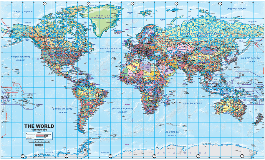
A world map is one of the most complicated cartographic art forms possible. We have published world maps in conjunction with other firms in years past, most notably the silk-screen-printed 5'x8' version, which is the largest single sheet map of the world ever printed. This map, for which we provide a picture included with this newsletter, uses a Miller Cylindrical (WGS 84) Projection at a scale of 1:30,000,000. It is a political map, with countries shown in differing colours, and uses hill shading relief to portray mountain chains. We have also included relatively shallow ocean depths, such as continental shelves and ridges, particularly in the Atlantic. Now, any map is only as good as its information, and this one is pretty good - how good only customers can determine. We've certainly done our best to spell everything correctly and to add enough place names and major highways to create a pleasing and informative map without over-loading it with detail. Every country is represented (naturally) including the new South Sudan. We have also included time clocks top and bottom. We have printed a modest initial print run, and many thanks to Dave Mecklenburg and his printing team for sorting out various technical underlying monstrosities. The two versions, paper and laminated, are identical in information and size (53"x32" or 135cm x 82cm) and are marketed flat, rolled in a plastic sleeve. For practical reasons, minimum quantities will apply for retailers and distributors.
Legend Includes:
Capital, State/Provincial Capital, Principal Cities, Other Towns/Cities, Mountain Summit (Height in Metres), International Boundary, State/Povince Line, Main Route, Main Railway, River, International Date Line and much more.
Preview (click to enlarge):